
2·
10 hours agothat looks good indeed, thanks for the recommendation!
that looks good indeed, thanks for the recommendation!
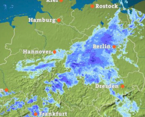
thanks, i tried it at some point and i just reinstalled it to have a look but it doesn’t seem to have a rain radar (unless it is hidden somewhere). i am looking for a map like this:
i use öffi for public transportation, maybe there’s something similar for your region? or maybe your region is already included, check here: https://oeffi.schildbach.de/

this looks like foobar2k, cool
I didn’t have great service in large patches of the route, but the gps works regardless, so as long as you have the GPX files, it should point you in the right direction.
it’d save a lot of battery when airplane mode is turned on in those areas as the phone doesn’t look for reception constantly
even older phones come with OLED screens these days, maybe there’s a display option to make use of that? (where the background is pure black = pixels are off)
i second an old phone with one of these: https://wiki.openstreetmap.org/wiki/OsmAnd#Bicycle_and_pedestrian_features
i personally use organic maps: https://f-droid.org/packages/app.organicmaps/
but conflicts still halt for user input
i never understood this behavior. starting a large data transfer only to come back an hour later to find it halted at 5% due to some conflict. why not put those files at the end of the queue and resume with the rest?
It detects conflicts, and lets you decide what to do.
does it continue to sync the rest on conflict or does it halt for user input?
purchase the tourist tech-buying guide she’s produced over the years
do you have a link for that?
and they go acquired by EA, i wonder if that had something to do with it…
it’s a shame how they ruined pvz2 with all the mtx cheats, nothing feels properly balanced and the sense of progression is completely absent.
not (completely) open source but signal has a “note to self” function i use for that
thanks, i’ll check it out!